


Breaking the Cycle in Ladakh


Okt 01
#15: Hunder - Khardung - Leh
Publiziert am 02:15
28th - 30th September
Days 26 - 28
Distance cycled - 154km
Total distance cycled - 1154km
Day 26
Distance - 59km
One of the main reasons for diverting to Hunder in the Nubra Valley was
to see the sand dunes, which would seem so out of place here. Located
just east of the town, the dunes cover a relatively small area (compared
to other places I have seen sand dunes, such as the Australian deserts
and the Sahara). The grey-coloured dunes look to be formed from river
silt, transported by the wind and built up over time. They are Sahara-
like C-shaped ergs, some (I estimate) are 10-12m high.
The other draw card for me were the Bacterian camels, I think a relic
from the days of the ancient Silk Route when goods would have been
traded from Central Asia. They are certainly built to haul loads over
very long distances, over high passes in extreme conditions; their coats
are very thick and fluffy to protect them from the cold, and their two
humps are like a double-sized energy store to sustain them on their
journey. The animals seemed more docile than my experiences of
dromedaries in Australia and Africa, but that could also have been
because the Hunder camels have been trained to be around people.
After spending an hour or so walking through the dunes and filming the
scenes, I set off for Diskit, the administrative capital of the region
and on to Khalsar, (36km) at the base of the big climb. From there, it
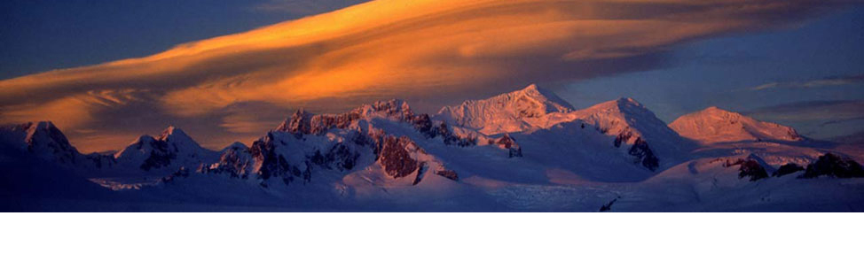
was a 23km ascent in one go to reach Khardung (approximately 3200m -
4000m) where I was to stop for the night.
The gradient was never particularly steep, (no more than 5%), but the
climb was long and relentless. For the first 10km, the road zigzagged
parallel to the Shyok valley below, then wound its way inland towards
Khardung village, the cold air settling in after about 3600m.
Day 27
Distance - 71km
But this was not even half of the ascent. From Khardung, the climb
continued for another 32km, to the famous Khardung La, one of the
highest motorable all-weather roads in the world at 5360m. Therefore,
from Khalsar to the top of the pass involved 55km of continual climbing,
gaining 2160m in altitude.
Knowing the day was going to require a huge effort, I set off from
Khardung in a determined mood, and felt I was making good, steady
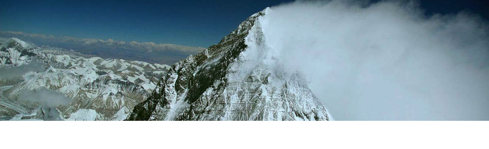
progress. Just before North Pullu (military village), the half way mark,
the morning suddenly turned very chilly, as I ascended through the snow
line, clouds bubbled over and a piercing, cold wind funnelled down the
valley, straight from the snow covered Khardung La. The road continued
to ascend at around a 5% gradient, but conditions were becoming more
challenging with the weather and the lack of oxygen. The looming pass
was in view from North Pullu and onwards.
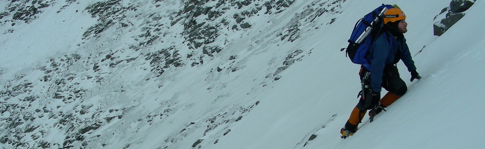
The good paved road ended with about 300m-400m still to ascend. Just
when I thought I had the pass under control, it became a whole lot
tougher - there is always a sting in the tail! The unpaved road was a
bumpy, rocky, and as I neared the pass, a muddy mess. I concentrated
hard to thread my way through the stony patches and bumps. The worst of
it at this point was the number of cars coming down from the pass, many
of them being Indian tourists who, unlike the local Ladakhis, had no
idea how to drive in such road conditions. I found myself not only
dodging the stones and mud, but also the cars and motorbikes of some
inexperienced and often rather stupid drivers. One speeding motorcyclist
clipped my handlebars trying to squeeze through a gap that wasn’t there
at speed. I managed to hold strong, but the usually quiet Dorjay
(driver) saw it all happen and let the motorbike rider have it - totally
out of character to stand up for me.
The final couple of kilometres were very slow, but I could see the pass up ahead and worked my way forwards. I could hardly speak on arrival at the pass as the back of my throat was frozen from trying to suck in enough oxygen. Still, I was there, amongst hoards of Indian tourists jockeying for position to have a selfie taken in front of the sign.
From there, all there was left to do was a 41km descent into Leh. The
first 10km wasn’t very pleasant because the unpaved road was muddy,
rough and there were a fair few cars and trucks. My hands became so
cold, even with long gloves on because my fingers were pulling hard on
the brake levers all the way. I had to stop at the first opportunity at
South Pullu (another military barracks) for a cup of Maggi noodles to
thaw out. After that, below 4600m, the temperature gradually warmed and
the road was good quality tarmac. The final 25km didn’t take long and
was a lot of fun!
Day 28
Distance - 24km
I decided to return to Leh a day earlier than planned in order to
capture more of the sights in and around the town. I cycled a leisurely
24km to visit Shey Palace and Thiksay Monastery, then returned to Leh to
wrap everything up.
Jigmet, the cameraman has been travelling with me for 4 weeks - the two
cycling journeys and the GHE expedition. He has done a great job, always
smiling, happy and he worked very hard, taking video and still images.
Dorjay, the driver for the second cycle tour also did a great job. He
doesn’t speak much English, but that didn’t matter. Jigmet was able to
translate.
This evening I have boxed my bike and have everything packed and ready
to fly out of Leh in the morning. It has been a great expedition with a
few challenges and it will take some time to absorb it all.
Days 26 - 28
Distance cycled - 154km
Total distance cycled - 1154km
Day 26
Distance - 59km
One of the main reasons for diverting to Hunder in the Nubra Valley was
to see the sand dunes, which would seem so out of place here. Located
just east of the town, the dunes cover a relatively small area (compared
to other places I have seen sand dunes, such as the Australian deserts
and the Sahara). The grey-coloured dunes look to be formed from river
silt, transported by the wind and built up over time. They are Sahara-
like C-shaped ergs, some (I estimate) are 10-12m high.
The other draw card for me were the Bacterian camels, I think a relic
from the days of the ancient Silk Route when goods would have been
traded from Central Asia. They are certainly built to haul loads over
very long distances, over high passes in extreme conditions; their coats
are very thick and fluffy to protect them from the cold, and their two
humps are like a double-sized energy store to sustain them on their
journey. The animals seemed more docile than my experiences of
dromedaries in Australia and Africa, but that could also have been
because the Hunder camels have been trained to be around people.
After spending an hour or so walking through the dunes and filming the
scenes, I set off for Diskit, the administrative capital of the region
and on to Khalsar, (36km) at the base of the big climb. From there, it
was a 23km ascent in one go to reach Khardung (approximately 3200m -
4000m) where I was to stop for the night.
The gradient was never particularly steep, (no more than 5%), but the
climb was long and relentless. For the first 10km, the road zigzagged
parallel to the Shyok valley below, then wound its way inland towards
Khardung village, the cold air settling in after about 3600m.
Day 27
Distance - 71km
But this was not even half of the ascent. From Khardung, the climb
continued for another 32km, to the famous Khardung La, one of the
highest motorable all-weather roads in the world at 5360m. Therefore,
from Khalsar to the top of the pass involved 55km of continual climbing,
gaining 2160m in altitude.
Knowing the day was going to require a huge effort, I set off from
Khardung in a determined mood, and felt I was making good, steady
progress. Just before North Pullu (military village), the half way mark,
the morning suddenly turned very chilly, as I ascended through the snow
line, clouds bubbled over and a piercing, cold wind funnelled down the
valley, straight from the snow covered Khardung La. The road continued
to ascend at around a 5% gradient, but conditions were becoming more
challenging with the weather and the lack of oxygen. The looming pass
was in view from North Pullu and onwards.
The good paved road ended with about 300m-400m still to ascend. Just
when I thought I had the pass under control, it became a whole lot
tougher - there is always a sting in the tail! The unpaved road was a
bumpy, rocky, and as I neared the pass, a muddy mess. I concentrated
hard to thread my way through the stony patches and bumps. The worst of
it at this point was the number of cars coming down from the pass, many
of them being Indian tourists who, unlike the local Ladakhis, had no
idea how to drive in such road conditions. I found myself not only
dodging the stones and mud, but also the cars and motorbikes of some
inexperienced and often rather stupid drivers. One speeding motorcyclist
clipped my handlebars trying to squeeze through a gap that wasn’t there
at speed. I managed to hold strong, but the usually quiet Dorjay
(driver) saw it all happen and let the motorbike rider have it - totally
out of character to stand up for me.
The final couple of kilometres were very slow, but I could see the pass up ahead and worked my way forwards. I could hardly speak on arrival at the pass as the back of my throat was frozen from trying to suck in enough oxygen. Still, I was there, amongst hoards of Indian tourists jockeying for position to have a selfie taken in front of the sign.
From there, all there was left to do was a 41km descent into Leh. The
first 10km wasn’t very pleasant because the unpaved road was muddy,
rough and there were a fair few cars and trucks. My hands became so
cold, even with long gloves on because my fingers were pulling hard on
the brake levers all the way. I had to stop at the first opportunity at
South Pullu (another military barracks) for a cup of Maggi noodles to
thaw out. After that, below 4600m, the temperature gradually warmed and
the road was good quality tarmac. The final 25km didn’t take long and
was a lot of fun!
Day 28
Distance - 24km
I decided to return to Leh a day earlier than planned in order to
capture more of the sights in and around the town. I cycled a leisurely
24km to visit Shey Palace and Thiksay Monastery, then returned to Leh to
wrap everything up.
Jigmet, the cameraman has been travelling with me for 4 weeks - the two
cycling journeys and the GHE expedition. He has done a great job, always
smiling, happy and he worked very hard, taking video and still images.
Dorjay, the driver for the second cycle tour also did a great job. He
doesn’t speak much English, but that didn’t matter. Jigmet was able to
translate.
This evening I have boxed my bike and have everything packed and ready
to fly out of Leh in the morning. It has been a great expedition with a
few challenges and it will take some time to absorb it all.
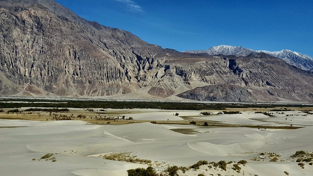
Hunder sand dunes from the road
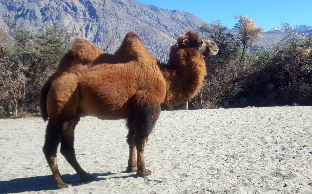
Bacterian camel
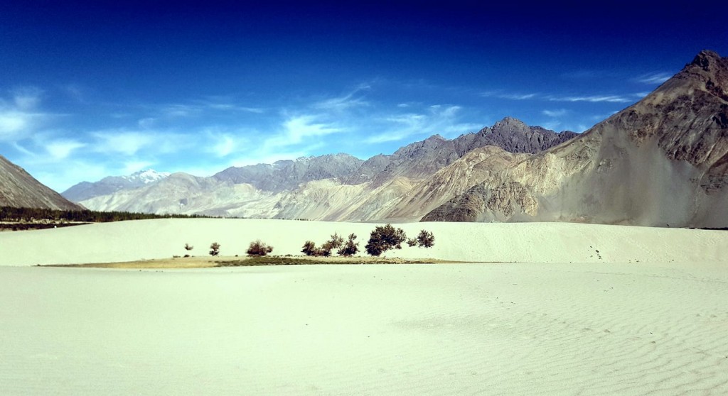
Hunder sand dunes

View of the Shyok River 2km into the climb from Khalsar
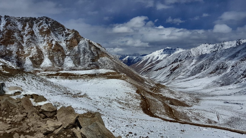
Near the top of Khardung La, just 100 more to climb
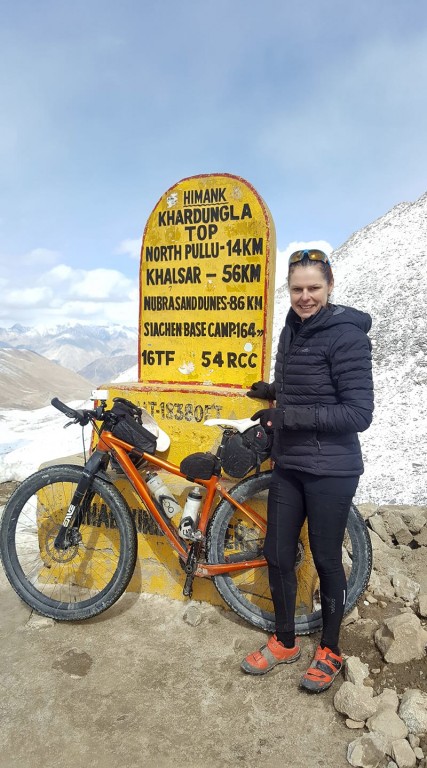
Pleased to arrive at the Khardung La Pass
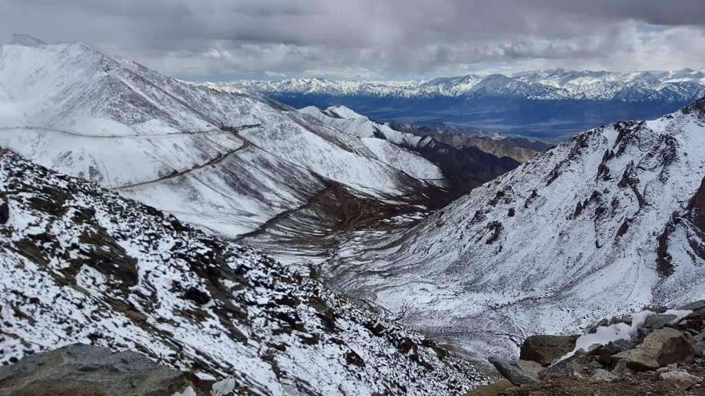
Looking down towards Leh, very cold
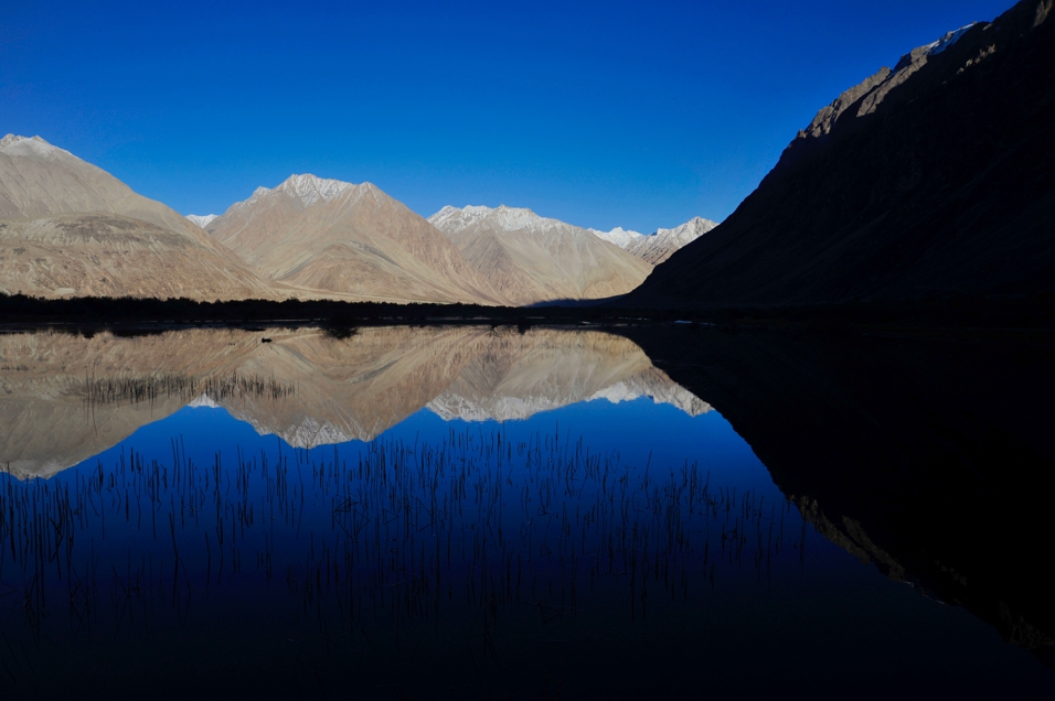
Reflections looking back towards the Shyok Valley, Nubra
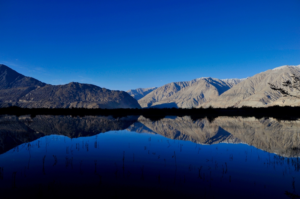
Reflections lookig towards the Nubra valley
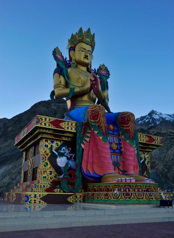
Maitreya Buddha at Diskit Monastery
Add Comment


Comments